We’d like to remind Forumites to please avoid political debate on the Forum.
This is to keep it a safe and useful space for MoneySaving discussions. Threads that are – or become – political in nature may be removed in line with the Forum’s rules. Thank you for your understanding.
Land at rear of property on orginal deeds
Comments
-
Yes I’ve done that but as it state on land registry this is what’s stated on land registry
The title plans of all registered titles show only the general position of the boundaries, unless they are shown as having been determined as exact boundaries pursuant to section 60 of the Land Registration Act 2002. This means that it is possible for an area of land to be within a registered title, even though it falls outside the red edging on the title plan. Conversely, it is possible for an area of land not to be included within the registered title, even though it is within the red edging on the title plan. In other words, it is not possible for HM Land Registry to define the precise position of the boundary in question.
If it turns out that the squatter, in fact, has documentary title to the land and what is really required is an alteration to the squatter’s and/or the squatter’s neighbour’s title plan to show the general boundary more accurately, then an application based on adverse possession is not appropriate. In these circumstances, the squatter should consider an application to alter either:
- their title plan
- their and their neighbour’s title plan
- their neighbour’s title plan
to show the boundaries more accurately.
Such an application would need to be made in form ap1 identifying the title(s) to be altered. The applicant would need to make clear the nature of the alteration sought and the basis for the claim. A fee would be payable assessed under the Fee order The determined boundary procedure could also be considered
And yes certain neighbours use the allotments directly behind their property but When I’ve asked do they own them they say no but I’m not sure they’ve looked or have the orginal deeds like I have dating back to the orginal lease of the property I’ve attached 1 of the documents I have
0 -
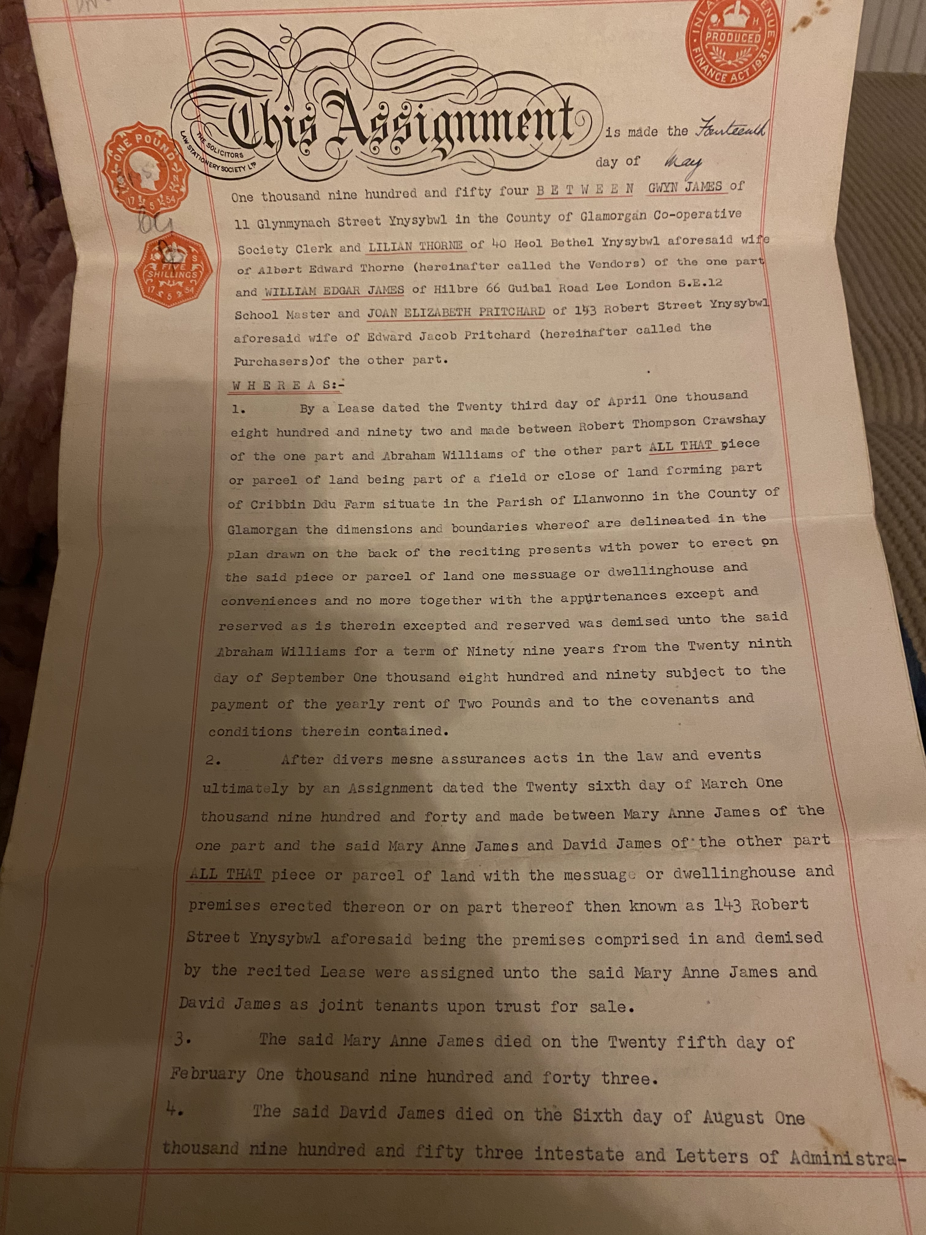 This is one of the orginal documents that I received when I bought my house1
 -
jbeechey92 said:This is one of the orginal documents that I received when I bought my houseWhich says nothing about an extra bit of land - it is talking about a bit of field on which the house will be built.That also suits, to my mind, the 1917 map being labelled allotments, because I associate that term more with centrally owned land, allotted out, than individually owned plots.But it does sound to me that if you want to use the allotment for its intended purpose you could probably easily and cheaply arrange to do so.But a banker, engaged at enormous expense,Had the whole of their cash in his care.
Lewis Carroll1 -
Il just use the land and see what happens 😂0
-
Personally I would not want to be adding land to my property that has Japanese knotweed on it!3
-
When you are reading old deeds, remember what they are describing isn't necessarily the same thing as what is currently there.jbeechey92 said:
...but on orginal deeds I was given with my property dated 1914 it mentions a parcel of land or field and the word messuage is used as well as dwelling house in discription of my property, also in the 1897 and 1898 os maps there’s no mention of allotment gardens on that map but in 1917 os maps and later it states allotment gardens, Robert Thomas crawshay owned the land around the village back in the 1800s until his death in 1940, I have all the orginal paper work regarding the lease of the land stating the fields parcel of land with a rite of a dwelling house and messuage so my thoughts are the land would have belonged to the property at some stage and the allotment society at some stage has applied for a adverse possession...
E.g. The 1954 assignment you've posted the first page of is only showing a 'recital' - the section headed "Whereas" - which is explaining the history of how a piece or parcel of land (with rights to erect a house) was demised to someone called Abraham Williams in 1892.
That piece or parcel of land (and the house) aren't necessarily your house and garden. It was whatever was shown on the plan referred to in that recital.
Without seeing that plan, it is far more likely - given that these are terraces of mineworkers(?) cottages - that your house came into being when someone bought a large plot of land and erected a streetfull of cottages, rather than your property being the one built as a result of the right referred to in 1892.
You say "the orginal owners family had the house since it was built" - but the 1954 assignment lists the vendors as living elsewhere and one of the purchasers already living in the property. That implies that the purchaser 'JEP' was renting the property from the vendors - so were these people really all part of the same family? My expectation would normally be for properties of this type to be built by a mineowner (or some other person) and rented out by them for many years before someone was able to afford to buy each house individually.
Therefore it would normally be more common for all the houses (and all the land behind) to be in a single ownership from the point they were built until the first one was sold off - and therefore not unlikely that the house and garden were sold separately from the communal allotment land at the rear. (just my guess though, you'd need to trace ownership through the deeds to be sure)
Whether or not OS maps refer to "allotment gardens" is not really that significant. It just depends on what the cartographer saw, and how much space they had to write in different words on maps of a particular type and scale.
The way these allotments have been shown divided up on the maps also varies significantly through the years - that too doesn't mean very much on its own, but possibly points towards all the allotments being in some form of common ownership (e.g. the allotment society) - there were certainly a lot of allotments in this village and them all being owned and managed by one organisation would be logical.
1 -
Sapindus said:Personally I would not want to be adding land to my property that has Japanese knotweed on it!
I would actually go a step further and have everything ready to report the allotment society to the EA as soon as it spreads off of their land.
0 -
All the history is very interesting, but it ignores the single most important factor...
What did the plan on the OP's purchase conveyance show?
What does the plan on his LR title show?
They're what really matter today...1 -
It’s already spread off the land and into the rear lane slightly I always chop it back to try and prevent it spreading closer to my garden, I’d happily clear the land if it was mine I’d remove and dispose of the knot weed scrape the top layer of earth off and dispose of as contaminated waste then treat the ground if it was my propertyciderboy2009 said:Sapindus said:Personally I would not want to be adding land to my property that has Japanese knotweed on it!
I would actually go a step further and have everything ready to report the allotment society to the EA as soon as it spreads off of their land.0 -
AdrainC
On the op paper work it does state a plan drawn but I don’t have that sadly I don’t know if it’s lost or if it would be in archives somewhere as the property was orginal leased by the crawshay family of Merthyr so there might be plans of property in archive some where but I’d have to do some hunting and research to find anything relating to my property it would be hard as I know the crawshays owned loads of land and property through out South Wales
0


Confirm your email address to Create Threads and Reply

Categories
- All Categories
- 354.5K Banking & Borrowing
- 254.4K Reduce Debt & Boost Income
- 455.5K Spending & Discounts
- 247.4K Work, Benefits & Business
- 604.3K Mortgages, Homes & Bills
- 178.5K Life & Family
- 261.8K Travel & Transport
- 1.5M Hobbies & Leisure
- 16.1K Discuss & Feedback
- 37.7K Read-Only Boards