We’d like to remind Forumites to please avoid political debate on the Forum.
This is to keep it a safe and useful space for MoneySaving discussions. Threads that are – or become – political in nature may be removed in line with the Forum’s rules. Thank you for your understanding.
PLEASE READ BEFORE POSTING: Hello Forumites! In order to help keep the Forum a useful, safe and friendly place for our users, discussions around non-MoneySaving matters are not permitted per the Forum rules. While we understand that mentioning house prices may sometimes be relevant to a user's specific MoneySaving situation, we ask that you please avoid veering into broad, general debates about the market, the economy and politics, as these can unfortunately lead to abusive or hateful behaviour. Threads that are found to have derailed into wider discussions may be removed. Users who repeatedly disregard this may have their Forum account banned. Please also avoid posting personally identifiable information, including links to your own online property listing which may reveal your address. Thank you for your understanding.
📨 Have you signed up to the Forum's new Email Digest yet? Get a selection of trending threads sent straight to your inbox daily, weekly or monthly!
The Forum now has a brand new text editor, adding a bunch of handy features to use when creating posts. Read more in our how-to guide
Land Registry - Possible land owner conflict
Comments
-
kensiko said:It is one of the things I have wondered, if someone went to the trouble of getting the title register deeds changed, why then did they not move the boundary back. It has always been on the same level as all the other houses since I have lived here. It has always just been a field that backed onto our property, although the field directly behind us was never used as it was always a slope down into the field.
There are many possible reasons - one example being that buying a piece of a field to incorporate into a residential garden might require change of use planning consent (agricultural to residential). It isn't uncommon for people to try and bypass the planning requirement by keeping the original boundary fence intact whilst starting to use the additional land for residential purposes. Then if nobody complains and the planning authority don't notice the change of use...
1 -
OC1 is the correct form
You’d have to read the caution title register to understand what the cautioner’s interest is. That may help understand why parts have been removed from that title
Whilst your neighbour’s title may be of some interest registration is on merit so just because next door is registered larger/smaller doesn’t mean your’s should match
All land is owned. Not all land is registered
And finally developers won’t always develop/sell plots right up to a boundary line. It gives them more control in s9me cases.Bottom line is you have plenty of information but not the remaining key pieces to understand everything fully
However if you have tried to take possession of someone else’s land and they can prove that they own it then providing it’s only a short period of time it’s likely they can legally remove you from it - your solicitor can advise“Official Company Representative
I am the official company representative of Land Registry. MSE has given permission for me to post in response to queries about the company, so that I can help solve issues. You can see my name on the companies with permission to post list. I am not allowed to tout for business at all. If you believe I am please report it to forumteam@moneysavingexpert.com This does NOT imply any form of approval of my company or its products by MSE"1 -
Thanks so much for your further advice. I am requesting a copy of the title plans of the large estate behind us to see where their boundary lies.Land_Registry said:OC1 is the correct form
You’d have to read the caution title register to understand what the cautioner’s interest is. That may help understand why parts have been removed from that title
Whilst your neighbour’s title may be of some interest registration is on merit so just because next door is registered larger/smaller doesn’t mean your’s should match
All land is owned. Not all land is registered
And finally developers won’t always develop/sell plots right up to a boundary line. It gives them more control in s9me cases.Bottom line is you have plenty of information but not the remaining key pieces to understand everything fully
However if you have tried to take possession of someone else’s land and they can prove that they own it then providing it’s only a short period of time it’s likely they can legally remove you from it - your solicitor can advise
The caution text is as below:
I have had a look into what "fee simple in possession is" and as I understood it the land is in use (I assume by the original farmer) and is freehold. But I could be mistaken.
I have more images to share as I used Google Earth to show the area of land from 2002-2020 where I have outlined the land in question on each image.
2002:
2008:
2017: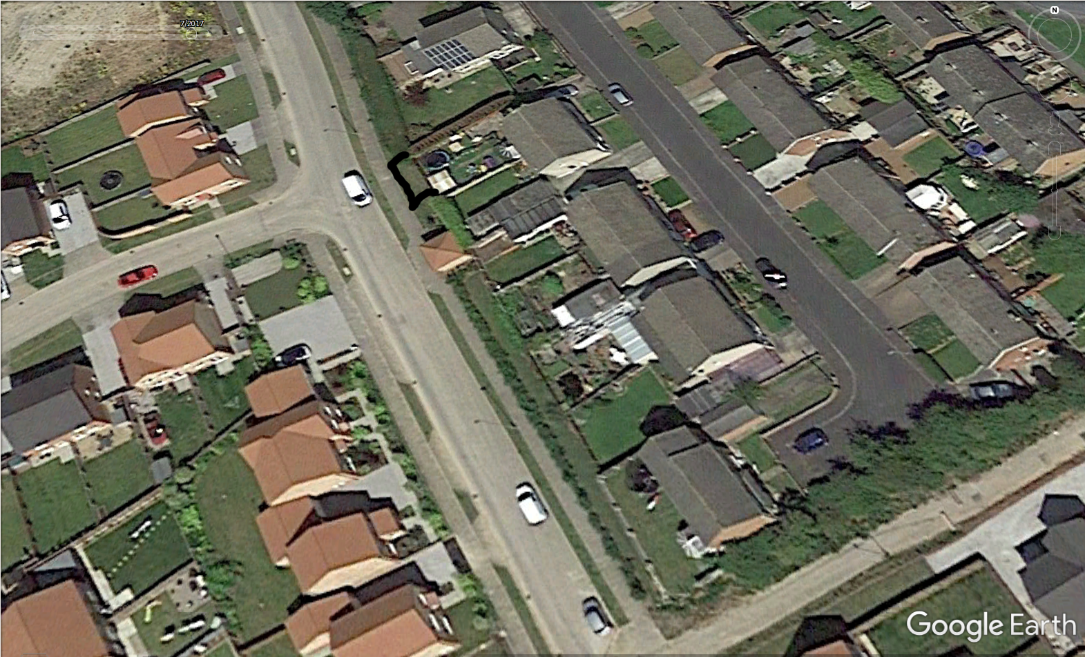
2020: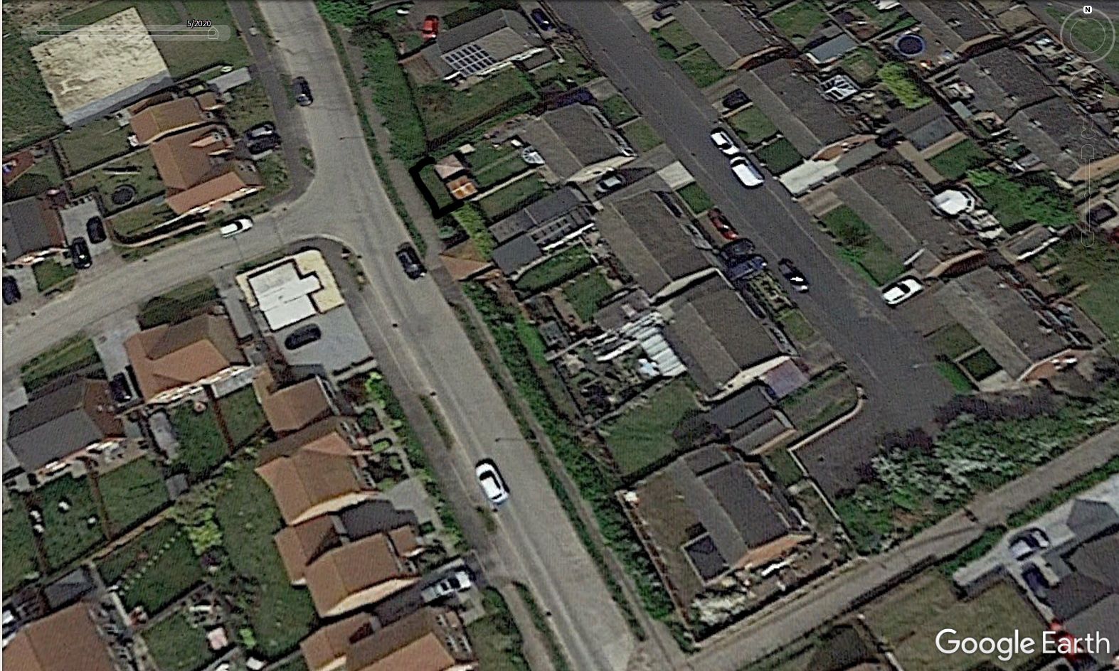
I fully agree if I have taken the land the fence will definitely be moved back, if I have misunderstood anything and will apologise to them. It's just frustrating as we did look into this before moving the fence and tried to contact the housing developer but had no response.
The fence has only been in it's new position for about 10 weeks now so they have been quicker to send a letter once it was noticed.
I think at this point I assumed my reasoning were correct and that maybe was why they didn't put the footpath nearer to my property.
Thanks you all for reading.0 -
2017 image shows a small new building two doors away which appears to be in a similar position to the area you are claiming. Is it a garage for that property? Its construction looks the same as the new houses.
1 -
That small building is an electric sub station for the new estate. Like most things on the plans that also looks like it is in the wrong place.Norman_Castle said:2017 image shows a small new building two doors away which appears to be in a similar position to the area you are claiming. Is it a garage for that property? Its construction looks the same as the new houses.
The final image of my original post shows that land (as it is a separate title deed for the electric company) as being further away from my neighbours border. In reality the substation backs directly onto my neighbours border touching it, as you can see in the satellite images.
The whole area seems to have been 'pushed back' in some way since the estate was built as they took all the land right up to all boundaries.
Thanks for pointing that out, hopefully that will make sense to others who look at the images.0 -
Yes, I was wondering what that was, appears built on builders land running along back of properties, which may be why they consider they own your fenced off bit area.Norman_Castle said:2017 image shows a small new building two doors away which appears to be in a similar position to the area you are claiming. Is it a garage for that property? Its construction looks the same as the new houses.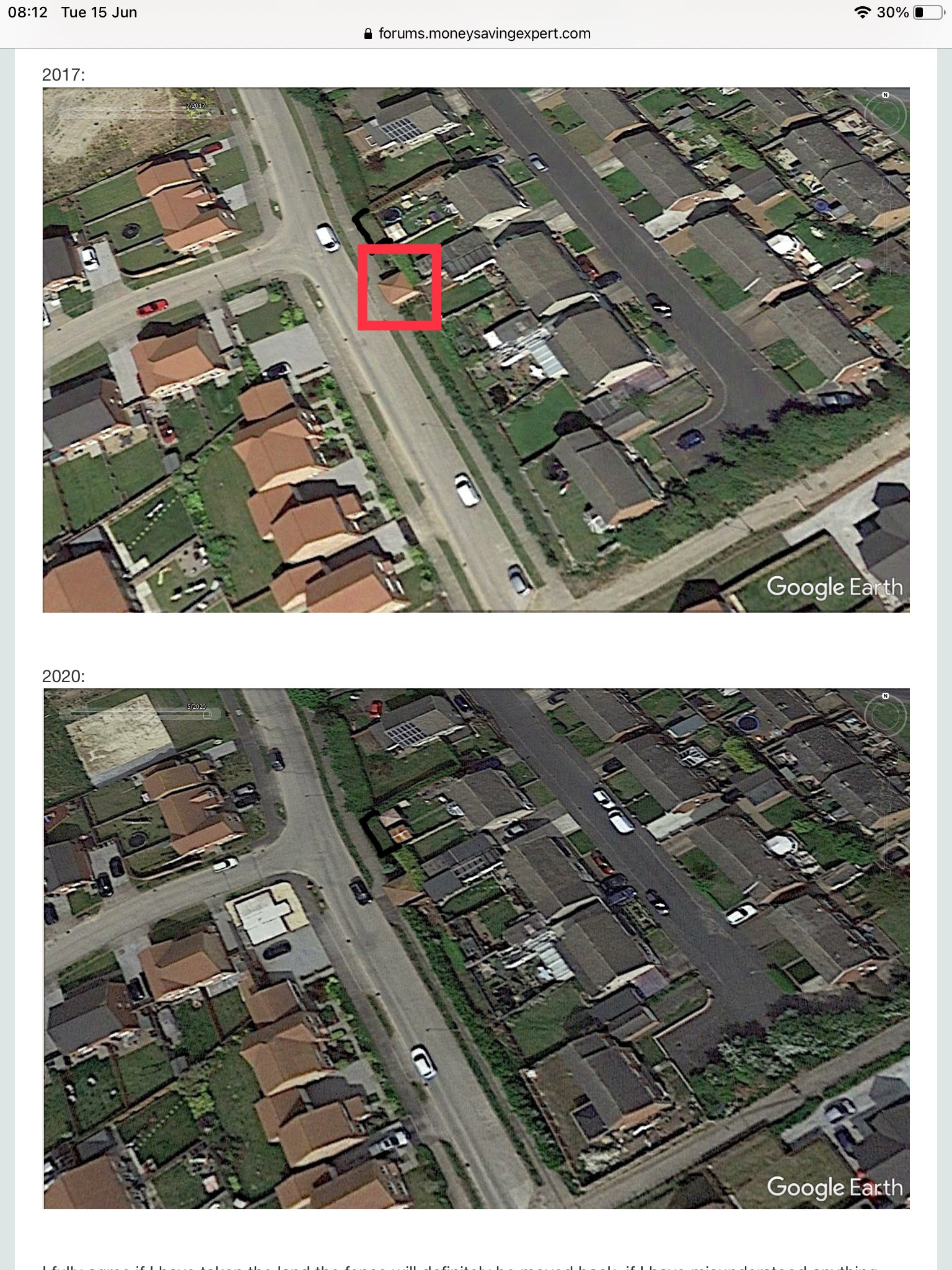 1
1 -
Absolutely that would make perfect sense as they have built the substation on that land. If I would have know about the extra land on my plans I would have queried this at the time but I just wasn't aware.UnderOffer said:
Yes, I was wondering what that was, appears built on builders land running along back of properties, which may be why they consider they own your fenced off bit area.Norman_Castle said:2017 image shows a small new building two doors away which appears to be in a similar position to the area you are claiming. Is it a garage for that property? Its construction looks the same as the new houses.
The question I suppose still remains, did this 'used' to be my land but now they have built on it it becomes theirs? That would seem a little bit unfair.0 -
Just one extra thing to note, this is just a personal thought and really has no basis in law as to who owns what.
If you look in the 2017/2020 images near the bottom you will see a row of trees that was planted by the housing development company. You can see (especially in the 2017 image) an area of unused land between the original boundaries and the row of hedging.
We were told on many occasions hedging would also be planted in the area at the edge of the land behind our property but it never happened.
What makes it funnier is some of the neighbours have complained that people can get into the area between their boundary and the trees undetected very easily. One of them asked Gleesons staff if they could push their fence further out and were told they could, albeit only verbally and I have no record of this.
I have left enough room for a hedging should they want to plant at the edge of my new fence but it seems odd that just because we never got the hedging it means we cannot move our fence out but if there was hedging (like there is near the bottom of the images) we may have been able to do it undetected just as others have been told they can use the unused land.0 -
Check the planning documents on the local council's website. There will normally be a plan showing the proposed landscaping and/or boundary treatment(s).kensiko said:We were told on many occasions hedging would also be planted in the area at the edge of the land behind our property but it never happened.
If the plan shows the developer was supposed to plant a hedge (rather than just doing it as a favour) then you could ask the planning enforcement team to require the developer to complete the hedge planting as per the consented plan.
If you have a look on old OS maps (e.g. on the NLS website here -
https://maps.nls.uk/geo/explore/side-by-side/ ) you can see that historically the boundary
where you are was within a group of buildings called "The *******s".
The extract below is from the "OS 25 Inch, 1892-1914" layer.
Rather than being a clearly defined and 'smooth' boundary (as at the top end of your road) along your section where the buildings were there are various features crossing what would otherwise be an almost straight-line boundary - with a small dog-leg roughly where number 20 on your road now is.
The "S" marks on the boundaries indicate where areas of land have been grouped together into a parcel (which has a parcel number I've redacted). That isn't proof of ownership, but is often indicative of which features appeared to belong together.
It isn't clear whether these buildings were the farm that owned the field the recent development is built on, or an unrelated property. But I would guess that part of the lack of clarity with the position of the current boundary stems from the irregularities that existed 100 plus years ago.
1 -
I have the original plans that the housing developer gave to the residents back in 2012/2013 and I have attached a cropped image of the full plan below. These are labelled 'planning layout' so I don't know how accurate they are to the finished estate.Section62 said:
Check the planning documents on the local council's website. There will normally be a plan showing the proposed landscaping and/or boundary treatment(s).kensiko said:We were told on many occasions hedging would also be planted in the area at the edge of the land behind our property but it never happened.
The sub station can be seen on here for reference.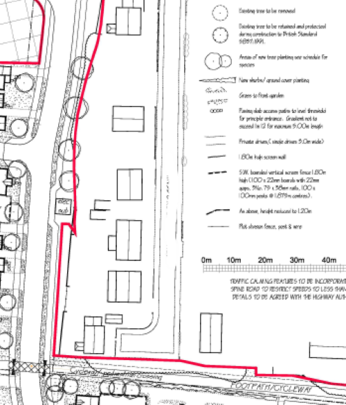
The site you mentioned is unbelievable. It's great to look back at how these places looked all those years ago
Thanks for pointing out all the information, I have looked at it all but I wont pretend to understand it all to be honest.
I do notice on the plans above though there is that 'dog-leg' you spotted.
If this goes back all those years, what chance is there that the more recent plans are now incorrect? I just find it strange that in 1989 the title deeds were edited with extra land but the more I look into it, the more confused I get!0


Confirm your email address to Create Threads and Reply

Categories
- All Categories
- 354.5K Banking & Borrowing
- 254.4K Reduce Debt & Boost Income
- 455.4K Spending & Discounts
- 247.4K Work, Benefits & Business
- 604.2K Mortgages, Homes & Bills
- 178.5K Life & Family
- 261.7K Travel & Transport
- 1.5M Hobbies & Leisure
- 16.1K Discuss & Feedback
- 37.7K Read-Only Boards