We’d like to remind Forumites to please avoid political debate on the Forum.
This is to keep it a safe and useful space for MoneySaving discussions. Threads that are – or become – political in nature may be removed in line with the Forum’s rules. Thank you for your understanding.
Stansted Airport NSL PCN - Is the PoFA 2012 "not relevant land" defence still vaild?
Comments
-
I read back over the thread earlier today. There is no attempt by NSL to hold the keeper liable in their NtK (front or back page), then they attempt to pull the keeper liability wool over the OP’s eyes in their appeal rejection in an attempt to unlawfully extort money from him. Bottom-feeding behaviour.Needs a complaint to the DVLA.Please note, we are not a legal advice forum. I personally don't get involved in critiquing court case Defences/Witness Statements, so unable to help on that front. Please don't ask. .
I provide only my personal opinion, it is not a legal opinion, it is simply a personal one. I am not a lawyer.
Give a man a fish, and you feed him for a day; show him how to catch fish, and you feed him for a lifetime.#Private Parking Firms - Killing the High Street4 -
OK, So I'm going down the POPLA route ith this, I'm not sure to choose:
"I was not the driver or the registered keeper of the vehicle at the time of the alleged improper parking."
oras their website states:"Other"
"Other grounds for appeal
Appeals based solely on the following grounds for appeal are less likely to be successful"
I'm not sure whether one needs to be NEITHER the driver or keeper for the first option to be valid, or am I overthinking this?
0 -
Other
Base is solely on no keeper liability2 -
Whilst the NtK may be non-PoFA, the operator is nevertheless purporting to impose keeper liability, which is unlawful on land subject to statutory control. The following wording makes that clear:
Should you provide an incorrect address for service, we may pursue you for any amount that remains unpaid. Should you identify someone who denies they were the driver, we may pursue you for any amount that remains unpaid. Failure to pay the full amount of this notice within 28 days may result in the proceeding of debt recovery action and/or issuing court proceedings against you. Additional costs may be incurred.
That language is not neutral. It is a clear attempt to hold the registered keeper liable regardless of driver identification, which is precisely what PoFA would be required for — and PoFA cannot apply on airport land.
On the airport boundary point, @cooldude255220 appears to be conflating the operational (airside) area with the airport boundary. The operational area is the restricted airside zone that requires security clearance. It is not the legal boundary of the airport.
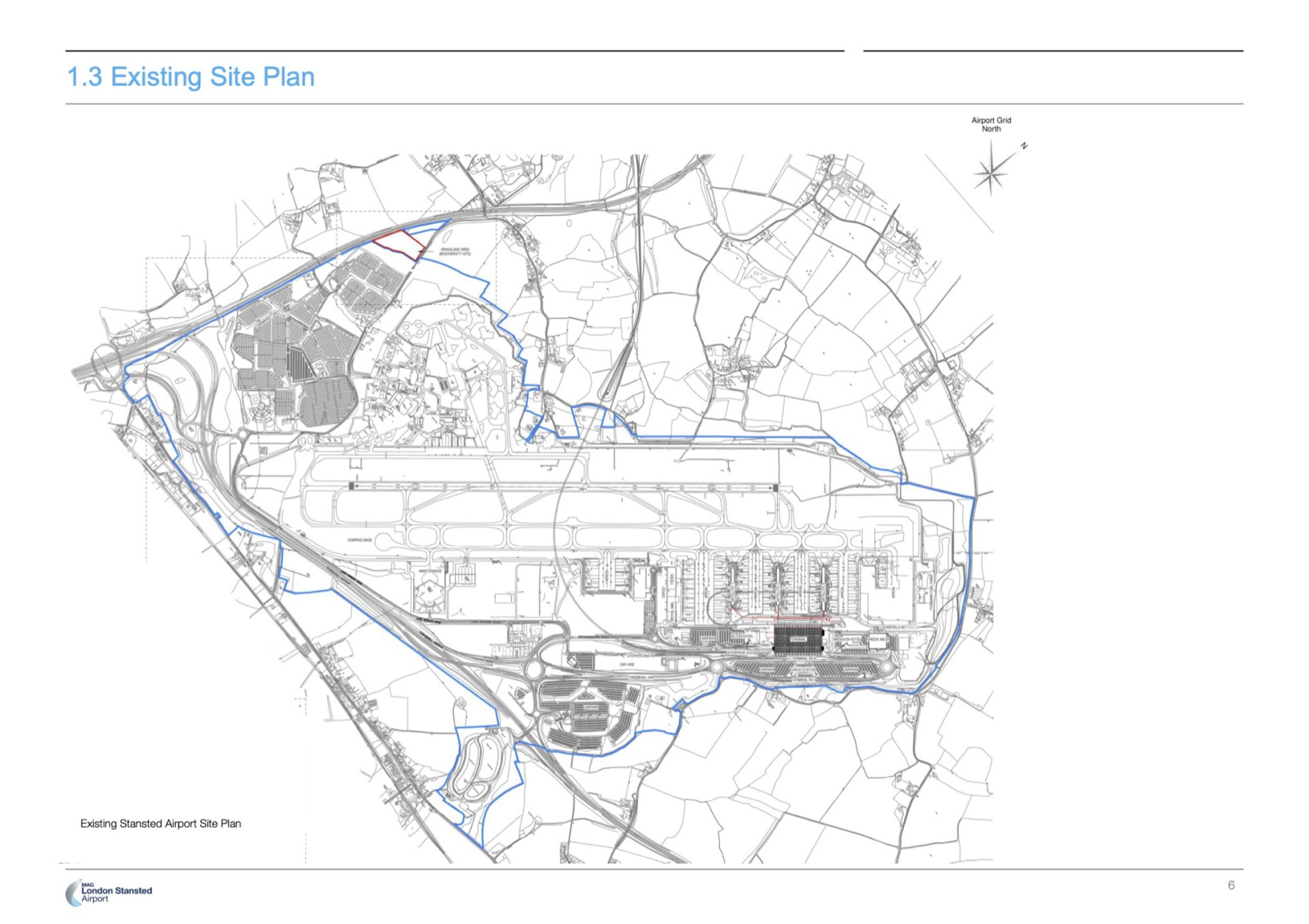
The airport boundary — i.e. the land to which the airport byelaws apply and which is therefore under statutory control — is the entirety of the land within the blue line on the site plan. That includes landside roads, car parks, and peripheral areas, not just airside. As such, this is not “relevant land” for the purposes of PoFA, and keeper liability cannot arise.So, the position is this: an NtK has been issued for an alleged breach of contract on land that is not relevant land for the purposes of PoFA. The NtK is not PoFA compliant yet nevertheless purports to impose keeper liability, which it cannot lawfully do. In any event, the signage relied upon is prohibitive and incapable of forming a contract.
Unless the PCN is cancelled at appeal, the only route open to the operator would be to attempt to advance the matter before a court. The operator would then be put to strict proof that a lawful contract existed, that the driver breached its terms, and that any liability could attach to the Keeper — all of which are fundamentally in dispute.
4 -
@doubledotcomdoubledotcom said:On the airport boundary point, @cooldude255220 appears to be conflating the operational (airside) area with the airport boundary. The operational area is the restricted airside zone that requires security clearance. It is not the legal boundary of the airport.
The airport boundary — i.e. the land to which the airport byelaws apply and which is therefore under statutory control — is the entirety of the land within the blue line on the site plan. That includes landside roads, car parks, and peripheral areas, not just airside. As such, this is not “relevant land” for the purposes of PoFA, and keeper liability cannot arise.
You are operating under the misapprehension that all airport land (i.e. all land within an Airport's boundary) is subject to bylaws. This is not necessarily true.
Most bylaws include a map showing where they apply; Stansted does not, so the area where they do apply is not certain.
It is one argument that, in the absence of an annexed nap to the contrary, the map you have posted is where the bylaws apply. But it is not necessarily correct. You are claiming that it where the byelaws apply but there is nothing to say that is so.
Just like it is another argument that, seeing as the byelaws can only apply in an aerodrome, then the aerodrome map lodged with NATS is where they apply. (And especially seeing as the NATS Aerodrome plan is not always limited to the operational area).
I have written to Stansted to request a copy of any map showing where they apply so we can answer the question authoritatively.3 -
Attempts to limit byelaw coverage by reference to “operational areas”, “airside”, or NATS aerodrome plans are misconceived. Those concepts relate solely to aviation safety and flight operations. They have no statutory role in defining the extent of airport byelaws. There is nothing in the Airports Act 1986, or elsewhere, that ties the geographical reach of airport byelaws to airside boundaries, operational area plans, or NATS maps.
The legislation deliberately distinguishes between an aerodrome, which is an aviation concept concerned with aircraft operations, and an airport, which is a broader statutory undertaking. Airport byelaws are not confined to the aerodrome operational area. They necessarily extend to landside roads, roundabouts, car parks, drop-off zones and ancillary land forming part of the airport undertaking.
Where airport byelaws do not include an annexed map defining their geographical extent, that does not mean their application is limited to airside or operational areas. Nor does it create uncertainty that allows the scope of byelaws to be redefined by reference to aviation documentation. The absence of a map simply means the extent of the airport must be determined by objective, authoritative material identifying what land constitutes the airport.
In the case of Stansted, the only definitive and formally published boundary of the airport is that shown in the Stansted Airport Development Plan documentation. That material was produced and submitted by Stansted Airport Limited itself as part of a statutory planning application. It expressly identifies the extent of the airport, states that the land within the airport boundary is approximately 957 hectares, and distinguishes the overall airport boundary from smaller planning application boundaries within it.
That boundary is not illustrative or informal. It is the airport operator’s own representation to the state, in a statutory planning context, of what land constitutes the airport undertaking. It therefore provides the only objective reference point for identifying the extent of the airport in the absence of a byelaw annex.
Accordingly, roads, roundabouts and other infrastructure falling within that boundary form part of the airport. Absent any express statutory instrument or ministerial action removing specific parcels of land from byelaw control, those areas remain subject to airport byelaws.
This is not an abstract issue. Operators such as MET argue at locations like Southgate Park that land within the airport boundary becomes “relevant land” merely because it is operated by a third party. That argument misunderstands public law. Airport byelaws are subordinate legislation. They do not lapse, fragment or disapply because land is leased, licensed or sold, nor because a private parking operator is engaged.
The correct legal question is not who operates or manages the land, but whether there has been any lawful act of the state removing that land from the scope of the byelaws. In the absence of strict proof of statutory disapplication, the byelaws continue to apply.
In short, aviation operational concepts do not define byelaw coverage, private land arrangements do not disapply statutory control, and the only authoritative boundary of Stansted Airport is the one the airport itself relies upon in planning law. Land within that boundary remains subject to airport byelaws, is not relevant land for PoFA purposes, and cannot give rise to keeper liability.
1 -
You've clearly not read my comment here, which talks about precisely how the legislation defines an airport (hint, it involves the aerodrome).doubledotcom said:Attempts to limit byelaw coverage by reference to “operational areas”, “airside”, or NATS aerodrome plans are misconceived. Those concepts relate solely to aviation safety and flight operations. They have no statutory role in defining the extent of airport byelaws. There is nothing in the Airports Act 1986, or elsewhere, that ties the geographical reach of airport byelaws to airside boundaries, operational area plans, or NATS maps.
The legislation deliberately distinguishes between an aerodrome, which is an aviation concept concerned with aircraft operations, and an airport, which is a broader statutory undertaking. Airport byelaws are not confined to the aerodrome operational area. They necessarily extend to landside roads, roundabouts, car parks, drop-off zones and ancillary land forming part of the airport undertaking.
Where airport byelaws do not include an annexed map defining their geographical extent, that does not mean their application is limited to airside or operational areas. Nor does it create uncertainty that allows the scope of byelaws to be redefined by reference to aviation documentation. The absence of a map simply means the extent of the airport must be determined by objective, authoritative material identifying what land constitutes the airport.
In the case of Stansted, the only definitive and formally published boundary of the airport is that shown in the Stansted Airport Development Plan documentation. That material was produced and submitted by Stansted Airport Limited itself as part of a statutory planning application. It expressly identifies the extent of the airport, states that the land within the airport boundary is approximately 957 hectares, and distinguishes the overall airport boundary from smaller planning application boundaries within it.
That boundary is not illustrative or informal. It is the airport operator’s own representation to the state, in a statutory planning context, of what land constitutes the airport undertaking. It therefore provides the only objective reference point for identifying the extent of the airport in the absence of a byelaw annex.
Accordingly, roads, roundabouts and other infrastructure falling within that boundary form part of the airport. Absent any express statutory instrument or ministerial action removing specific parcels of land from byelaw control, those areas remain subject to airport byelaws.
This is not an abstract issue. Operators such as MET argue at locations like Southgate Park that land within the airport boundary becomes “relevant land” merely because it is operated by a third party. That argument misunderstands public law. Airport byelaws are subordinate legislation. They do not lapse, fragment or disapply because land is leased, licensed or sold, nor because a private parking operator is engaged.
The correct legal question is not who operates or manages the land, but whether there has been any lawful act of the state removing that land from the scope of the byelaws. In the absence of strict proof of statutory disapplication, the byelaws continue to apply.
In short, aviation operational concepts do not define byelaw coverage, private land arrangements do not disapply statutory control, and the only authoritative boundary of Stansted Airport is the one the airport itself relies upon in planning law. Land within that boundary remains subject to airport byelaws, is not relevant land for PoFA purposes, and cannot give rise to keeper liability.
https://forums.moneysavingexpert.com/discussion/comment/81839563/#Comment_818395631 -
Very interesting, as indicated on the terminal expansion planning map (above) the 'airport' encompasses a vast area, including the A120 trunk road, and right up to the edge of the B1256 in places. The byelaw demarcation roadsign is well within the area enclosed by the blue line - at the end of the A120 eastbound exit slip to the airport on Bassingbourn roundabout (see google maps & streetview). It will be interesting to see what the airport's reply is on this matter. I presume the trunk road status of the A120 would overule any byelaws?1
-
Are we not making heavy weather of a very easy case2
-
I agree.ChirpyChicken said:Are we not making heavy weather of a very easy case
But then I go into the nth degree when addressing the MHCLG on VERY easy points that they still don't comprehend, like banning the extortion of the fake 'escalation' fees.
It is absorbing to get into the detail sometimes!PRIVATE 'PCN'? DON'T PAY BUT DON'T IGNORE IT (except N.Ireland).
CLICK at the top or bottom of any page where it says:
Home»Motoring»Parking Tickets Fines & Parking - read the NEWBIES THREAD3


Confirm your email address to Create Threads and Reply

Categories
- All Categories
- 354.6K Banking & Borrowing
- 254.5K Reduce Debt & Boost Income
- 455.5K Spending & Discounts
- 247.5K Work, Benefits & Business
- 604.4K Mortgages, Homes & Bills
- 178.6K Life & Family
- 261.9K Travel & Transport
- 1.5M Hobbies & Leisure
- 16.1K Discuss & Feedback
- 37.7K Read-Only Boards